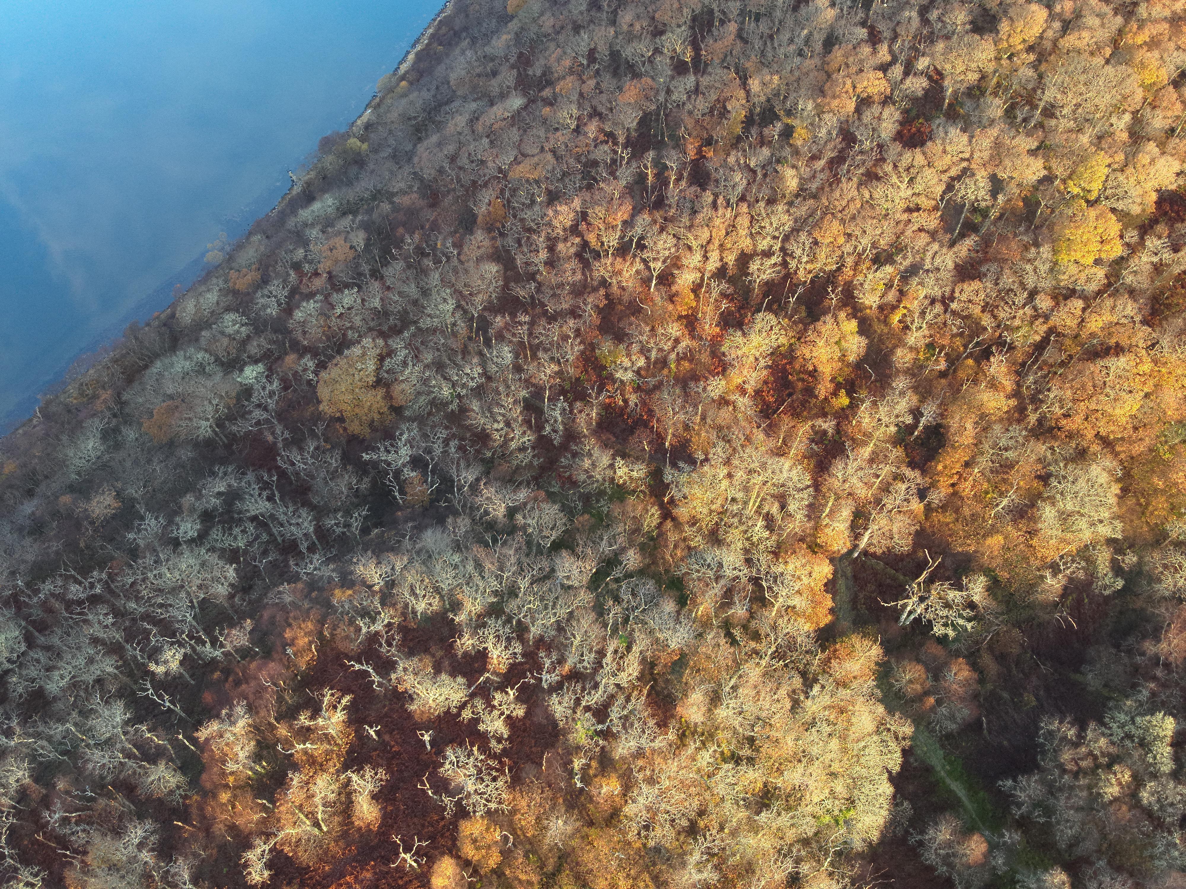
Over a fifth of Scotland is covered by peaty soils. Soils built up over thousands of years – mainly by sphagnum mosses as they grow and die down. Layer upon layer, turning from lush carpets of green, gold and red to sometimes metres-thick blankets of dense, black peat. Without healthy sphagnum mosses there are no healthy peatlands.
To mark National Plant Health Week, we thought it would be a good time to talk about sphagnum mosses. Partly to explain why it’s so important they are healthy – but also because they are fascinating plants in their own right!
There are over 30 different species of sphagnum mosses found in the UK – and at least 380 worldwide. It’s this variety that gives those peatland carpets their beautiful patterns of colour and texture. Different species come in shades from deep red to vibrant orange, dark forest-green to palest eau de Nil. They each have their favourite positions across the bog – some preferring wetter, some drier conditions, some liking shade while some are sun-lovers.
The diversity of these mosses is what also makes sphagnum so good for other wildlife. The mounds and hollows, ridges and pools produced by these miniature plants create ideal homes for a wide variety of other plants and animals. You’ll find tiny insects and spiders, sundews and bog cotton, for example, and the bigger creatures that then feed on them – like dragonflies and moths, birds and lizards.
And it’s also what makes peatlands so good at slowing the flow of water off the hills. The rough surface of the bog that sphagnum creates is perfect for trapping rainfall, releasing it slowly instead of letting it rush off the surface to flood land lower down the catchment.
But sphagnum mosses do this for their own benefit – not ours! By each having their own niche across the surface of the bog they can avoid competing with each other for space, meaning they can all get enough moisture, light and nutrients for their needs. However, all sphagnum mosses need a lot of water. They don’t have any roots, so rely on growing in a very wet environment where they can absorb the water though their tissues. As they grow and rot down, they actually alter their environment to make it more hospitable for themselves – and less so for other plants.
In their sphagnum species showcase, the IUCN UK Peatland Programme describes how sphagnum takes up calcium and magnesium ions in the water, and puts out hydrogen ions, which makes the environment more acidic. These mosses like acidic conditions, as many other plants can’t grow and compete with them so easily. They also have compounds in their cells which inhibit decomposition. This slows the rotting process when they die, keeping the nutrient level low, which again stops other plants competing so successfully. It’s an added benefit for us that this builds up layers of carbon-rich peat that are vital to helping us tackle our CO2 emissions.
This is why water table needs to be near the surface on peatlands; to keep the sphagnum – the building blocks of the bog – healthy and growing. If the peat is drained, grasses, trees and heather start to encroach on the drying ground, beginning a vicious circle where the more vigorous plants start sucking the water out of the peat, making it drier still.
While some of Scotland’s peatlands are in good condition, over three quarters of them have been damaged, making it difficult for sphagnum mosses to thrive. Peatland ACTION is working hard to reverse this damage. Peatland restoration aims to raise the water table again, allowing sphagnum mosses to re-establish and create those healthy, multi-coloured carpets that are so important for the wildlife, and people of Scotland.
As part of Wader Week, we’re continuing to shine the spotlight on wading birds and the threats they face. In today’s blog, NatureScot Ornithologist and Working for Waders Chair, Dave Parish gives us an insight into the various species, their habitats and lifestyles.
Working for Waders focuses on five key Scottish species – curlew, lapwing, golden plover, redshank and oystercatcher. These birds are probably what we think of when we hear the word “wader”, but there are around 210 species of wading birds in the world, and they enjoy a huge variety of habitats and lifestyles. Most waders are characterised by long legs and often a relatively long bill; many spend time wading in coastal areas, feeding on invertebrates in the wet mud, but the breeding season draws them into a range of different inland habitats.
Waders generally breed in open, treeless habitats where they can see all round and keep watch for approaching predators. This is crucial as the majority of waders lay their eggs in open nests on the ground and are vulnerable to predators like foxes and badgers (as well as avian predators like crows). But this view simplifies a plethora of breeding systems.
Take the lapwing, for example – a widespread, familiar species in Scotland (for now). During surveys of breeding lapwing, we usually record the number of pairs seen. This is often simply the total number of birds that were likely to be breeding, divided by two. In fact, research on colour-ringed birds where individuals can be identified, has shown that up to 30% of male lapwings probably have at least two mates. The females in these cases end up doing more of the incubation themselves than those in monogamous relationships, but the male does chip in. This is not an uncommon mating system amongst waders. However, it is taken to the extreme by the ruff, a scarce breeder in the UK. In this species, the males are considerably larger than the females and during the breeding season have an elaborate puffy collar (hence the name), and they gather together in display areas called leks where they try to gain favour with watching females. If successful, they mate but the male will then leave the female to do all the parenting alone whilst he continues displaying in the hope of catching the eye of another female.
A similar, but less common, breeding system can be found where the females mate with multiple males. The females hang around after mating for a few days whilst they lay eggs and then leave the males to hatch and raise the chicks whilst they go in search of another mate, or at the end of the season, leave the breeding grounds entirely. This is called polyandry and occurs in some tropical waders like jacanas.
Once breeding is over, tropical waders generally stay in roughly the same location throughout the year, because the conditions are relatively stable and food supplies are predictable. For waders breeding in our part of the world, things are very different in the winter compared to the summer, and finding enough food to stay alive can become impossible, so Scottish birds usually move. Some species are reactive and move just as far as they have to in order to find suitable foraging areas – usually around the coast where soft mud can always be found. This would include species like the lapwing, which often remain relatively local to the breeding grounds in winter, perhaps travelling from Scotland to Ireland or parts of France at most if necessary. Other species can be counted amongst the most travelled birds on the planet, undertaking huge migrations to the other side of the world. Our own dunlin, for example, breeds in northern Scotland and makes the long trek to southern Europe and North Africa for the winter, but this pales alongside the little stint. This is a tiny bird, lighter than a sparrow, but it flies between the Arctic and South Africa or Asia each year!
Waders from a number of separate breeding grounds may converge on the same wintering areas, or travel through shared ‘stop-over’ sites on their way to them, and this can lead to some spectacular gatherings. In some parts of the world, millions of waders can be seen where conditions combine to create perfect foraging areas. We don’t have anything quite like that in Scotland, but you can see thousands of waders in some estuaries during the winter, like the Moray Firth, Montrose Basin and the Firth of Forth, so if you fancy checking out these amazing birds, go along and see for yourself.
Working for Waders is a collaborative project aiming to reverse the decline of wading birds in Scotland. Partners include farmers, crofters and gamekeepers working alongside, and with support from, RSPB Scotland, the British Trust for Ornithology, the Game & Wildlife Conservation Trust, Scottish Forestry and NatureScot.
Today marks the start of the first ever Wader Week (6-12 May) and to celebrate, we asked NatureScot Ornithologist and Chair of the Working for Waders partnership, Dave Parish to tell us about it in today’s guest blog.
Welcome to the very first Working for Waders Wader Week! Between now and Sunday, we will share with you some fascinating facts about these wonderful birds, we’ll discuss some of the reasons behind their current declines and also some of the many success stories showing how we can help them.
We hope too that you will share your wader stories and experiences with us – we’d love to hear them. Are you lucky enough to still have birds breeding near you? Which species is your favourite? Are there any particular problems they face in your part of the country? Have you seen any odd behaviour (look out for our post later on the unusual places oystercatchers nest)? And if you have any photos you are willing to share, please post them.
Waders are starting to breed at this time of year so there is lots of nesting activity out there: if you want to take pictures of nests please remember to be quick, don’t get closer than you have to and be extremely careful. Try to leave no trace of your presence. Remember, breeding birds are protected by law for good reason. If the adults are away for too long, eggs and chicks are vulnerable to predation and exposure to the weather.
A lapwing nest. Image credit Marlies Nicolai
Amongst the many topics that we will be touching on this week will be the problems waders encounter in a changing landscape and in the face of increasing numbers of predators, and some of the challenges that land managers come up against when trying to help waders. We’ll describe some of the projects underway where practitioners have made a real difference and turned around the fortunes of their local birds, and describe some of the simple ways you can get involved, whether you are a land manager or just a wader enthusiast.
A curlew standing in long grass. Image credit Lorne Gill/NatureScot.
Throughout the week, if you have any comments or questions, please get in touch. You can respond directly to any of our online posts, or contact us on the Working for Waders website. We hope that Wader Week will become a regular feature in our calendars, so if you have any suggestions for stories we can include in future, or any projects (no matter how small) you would like to share and that perhaps we could visit, please let us know.
Working for Waders is a collaborative project aiming to reverse the decline of wading birds in Scotland. Partners include farmers, crofters and gamekeepers working alongside, and with support from, RSPB Scotland, the British Trust for Ornithology, the Game & Wildlife Conservation Trust, Scottish Forestry and NatureScot.
This week, ecologist and herpetological specialist Stephen Corcoran shares some fascinating information about adders and how our peatland areas support them.
Bogs are commonly thought of as bleak, inhospitable places, with little value. Yet, closer examination reveals that these wetlands are home to an amazing diversity of plants and animals. It may surprise many people that peatlands support all the four native terrestrial reptiles in Scotland, with adder and common lizard being particularly common on bogs.
The adder is the UK’s only venomous snake and is found through a range of habitats, across the Scottish mainland and several islands. It is a small snake, usually only around 60cm long but with some females as big as 80cm. It has distinctive zig-zag markings down the centre of its body; these are black on males and dark brown on females. Body colour can be very variable: silver-grey or brown or even ginger with black or melanistic adders are common in some places like Arran. They can live for over 30 years with the main predators (apart from humans) being some birds of prey and non-native pheasants.
Adders are usually active from March to October and hibernate over the winter. They hibernate in sites known as hibernacula, quite often with other adders or reptiles and amphibians. They are very faithful to these sites, returning to the same hibernacula each autumn. Hibernaculum can be places like ruined buildings, stone walls, piles of rocks, rabbit burrows, peat banks, tree roots or timber stacks. They need to be dry and frost free. One of the greatest risks to reptiles on peatland sites is the loss of hibernaculum features, either directly or through raising the water table.
Spring is the best times to see adders, as they come out of hibernation, need to spent time basking in the sun, shed their skins and find a mate. They can often be seen on south-facing slopes that have thick vegetation for cover. In peatlands, this can often be on old peat banks, gullies, and sheltered slopes. Usually mornings are best, on days with sunshine and cloud, with low winds and not too hot. On days with high winds, rain, and little sun you are unlikely to see adders.
Bogs provide important areas for food. Adders use them to hunt lizards, frogs, toad, voles and shrews, invertebrates, and small birds. Adders have superb camouflage and can be difficult to spot against the variety of colours across a bog. They will use all types of peatlands, even degraded bogs, and those at altitude. Plantations on bogs that were felled but not restored can become very good adder habitat after three or more years.
When seeking a mate, male adders will compete with other males for a female with a type of wrestling match known as “the dance of the adders”. After mating, adders move to wetter areas like bogs to feed, and can disperse more than a kilometre from their hibernation sites. They are good swimmers and can be seen swimming across rivers, lochs and even in the sea between islands. The pregnant females do not disperse far, spending extended periods basking and do not usually eat. They give birth to live young from August, usually around 4-10 young, which are venomous from birth. The ginger-coloured juveniles are left to their own devices.
Adders are a protected species and are unfortunately in decline due to a mixture of habitat loss, persecution, disturbance, or inappropriate habitat management. Peatlands are a vital habitat for this species, and other reptiles, and restoring bogs will be good for adders, as well as biodiversity in general.
All peatland restoration projects should consider reptiles from the outset and have a reptile mitigation plan, and consider creating artificial hibernacula. Some survey work and habitat assessment should be carried out before any work starts. In particular, possible hibernation sites need to be identified and protected during works. The timing of restoration should try to avoid work on site during the key emergence and breeding periods in late February to early May. Guidance on working in peatlands is available from the Amphibian and Reptile Groups of the UK.
Adders are quite timid and avoid humans; they only bite if cornered and threatened or if accidently trod on. Most people get bitten trying to pick one up! Anyone who is bitten by an adder should seek medical attention. A bite is rarely fatal though. Dogs can die from adder bites, and you should always keep them on a lead in known adder areas or if you see an adder: seek a vet if your dog is bitten.
If you do see an adder, keep your distance (no closer than three metres), and do not provoke it. Back away a little and crouch down and observe this magnificent animal. Use a zoom lens to take a photograph. It is especially important to avoid disturbing females as they can abort or re-absorb their young if stressed.
Adders are difficult to spot and very under-recorded, so if you do see one, please submit your sighting to www.recordpool.org.uk or https://irecord.org.uk/ or your local record centre. Say where and when you saw it, and include a photograph if you took one.
Adders, like other reptiles, will shed their skins, usually after hibernation and sometimes again in late summer. If you do find a shed skin or slough, you can also send these off to the Amphibian and Reptile Conservation Trust’s Reptile Genebank Project: https://www.arc-trust.org/genebank.
Next time you are out on a peatland site on a sunny day, keep a look out and you never know what you might see in front of you. If you are lucky, there might be an adder!
In his short life (1766-1802), Thomas Garnett, a native of Westmoreland, achieved a substantial amount. In addition to being a member of a number of learned societies in Scotland, England and Ireland, he became a Professor of Natural Philosophy and Chemistry in the Royal Institution of Great Britain and was highly regarded as a lecturer. His importance, in a Scottish Gaelic context, lies in his authorship of a two-volume work called ‘Observations on a Tour through the Highlands and part of the Western Isles of Scotland’. He was a close observer of the Highland scene and in his introduction, he explains that his approach as an author was to entice readers ‘from the straight path of the tour, to take a glance at the secret operations of Nature, and that the slight taste which they would thus have of her dainties, might give them a relish for a more sumptuous repast.’
His work was not without controversy, as he wrote of the ‘wretched situation of the inhabitants in the Highlands’ but he claimed that his intention was to ‘increase the comforts and remove the distress of the natives’. He recognised that his honesty would give offence to some persons, particularly ‘those who have it in their power to ameliorate [the Highlanders’] condition’.
Garnett left Glasgow on the 9th of July 1798 and headed first down the Clyde and north to Loch Lomond. In this blog I shall look at his comments about Loch Lomond and, most particularly, the names and characteristics of its beautiful and unique freshwater islands.
Garnett and his companion, a young gentleman artist ‘Mr Watts’, first encountered a Loch Lomond island close to the village of Luss, where they visited the Rev. Dr. John Stuart, ‘a man of great taste and learning’ who was engaged in the translation into Gaelic of the Old Testament (his father having superintended the translation of the New Testament a generation earlier). Stuart had a superb garden that lived up to the name of his adopted village (the name Luss coming from the Gaelic lus ‘plant’). Garnett was impressed by the fact that the churchman had planted his garden with many rare species, including native alpines from all over the Highlands and Islands.
Stuart organised a boat and boatman for Garnett and Watts to be taken out to Inchtavannach, the closest major island to Luss which is in extent about 150 acres and was at the time uninhabited and covered largely with ‘wood and heath’. Garnett correctly interprets the name of the place as ‘the island of the monk’s house’ – no doubt under the guidance of the scholarly minister. In Gaelic this is Innis Taigh a’ Mhanaich. It is connected in tradition to St Kessog.
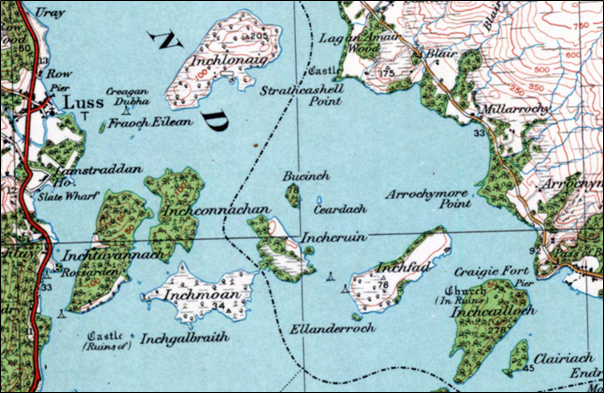
A gathering of innis island names (usually anglicised ‘inch’) near Luss on Loch Lomond. Clairiach at bottom right is a typographical error for Clairinch, given as Clairinish (Clàr Innis ‘flat island’) on modern maps. Reproduced with the permission of the National Library of Scotland
The highest point of the island – Tom nan Clag ‘the hill of the bells’ – provides a superb viewpoint and from it Garnett was able to spy virtually all of the many islands in Loch Lomond. To the south was Inchmurrin, upon which only a gamekeeper and his family were then resident. This is Innis Mearain ‘the island of St Mirren or Mirin’, a 6th century churchman. In Garnett’s time it was owned by the Duke of Montrose, although he notes that the island boasts the ruins of an old castle which was once a ‘habitation of the Earls of Lennox’. To its north-east is a chain of four islands of which the furthest east is Inchcailloch which Garnett correctly translates as ‘isle of Nuns’ (Innis Cailleach). It is connected to St Kentigerna (died 733 AD) who had a nunnery there, and it was once a burial place of the MacGregors. As well as being well wooded (which it still is), the island was inhabited in Garnett’s day and produced good crops of wheat and oats.
The reader who has some familiarity with the Gaelic landscape will have already noted that the default generic for ‘island’ in Loch Lomond is not the common eilean of the more modern era, but an older word – innis – also used in Irish Gaelic and which has a Welsh cognate – ynys. While pronounced ‘IN-eesh’ in Gaelic, it is generally anglicised ‘inch’ in Scottish place names. In Loch Lomond, as evidenced by the island names, we are dealing with an unapologetically old Gaelic landscape. This is compounded by the fact that some of the islands bear a largely unfamiliar word order, where innis is terminal rather than initial. The three other small islands at the southern end of the loch are Creinch (Craobh Innis ‘tree island’) which was covered with an oak wood in 1798 (Garnett gives its name as ‘Grange’, showing the pronunciation but failing to recognise the etymology of the name), Torrinch (Tòrr Innis ‘hill island’) and Clairinch (Clàr Innis ‘flat island’); the last is given as Inch-Clear i.e. Innis Clàir by Garnett, demonstrating a more ‘modern’ word order than exists on the current OS maps.
Garnett makes interesting observations about a tiny islet near the mouth of the Endrick Water at the south-eastern extremity of Loch Lomond. On modern maps it is named Aber Isle but he gives it as Inch-Aber i.e. Innis Abair ‘river-mouth isle’. Garnett claims aber as a Gaelic word, rather than recognising its origin in the P-Celtic Brittonic language but this is perhaps understandable, given the construction of the toponym (and, no doubt, following advice from the Rev. Stuart). It is possible that aber was loaned into Gaelic and became active within the language for a period, although the place name scholar W.J. Watson tells us that ‘it does not occur in Gaelic literature or in common speech [and] appears to have been displaced at an early stage in the language by the purely Gaelic term inbhear.’
The term inbhear (or, more commonly inbhir) does appear in one of Loch Lomond’s islands – Inveruglas Isle at the northern end of the loch. This is named for Inveruglas or Inbhir Dhubh-ghlais ‘mouth of the dark stream’ on the adjacent mainland shore.
To the immediate north of Inchcailloch is Inchfad which is Innis Fhada ‘long island’ (it is rather long and narrow). Five ‘innis’ islands stand between Inchfad and Inchtavannach. There is Inchcruin or Innis Cruinn ‘round island’, reputedly named for a rounded peninsula on its eastern side. In Garnett’s day it was largely unwooded and housed an ‘asylum for insane persons’. To its immediate west is the broad island of Inchmoan or Innis Mòna ‘peat island’, long a source of domestic fuel for the people of Luss and the surrounding area. North of this is Inchconnachan or Innis Chonachain ‘Colquhoun’s isle’ which was ‘covered with oak and fir’. The other two islands in the group are Bucinch (Boc Innis ‘buck [goat] isle’) and Inch Galbraith, a tiny crannog (artificial island) which supported a medieval castle owned by the Galbraiths.
To the north of these islands, immediately east of Luss, is the large island of Inchlonaig which has a fascinating history and ecology. Garnett noted that it contained ‘above 150 acres, one-half of which is covered by a natural wood of old yews, some of them very large. When bows and arrows were in use, this island was of great value, and the trees were preserved with the utmost care.’ Oral tradition tells us that it was King Robert the Bruce who first ordered the planting of yews to supply bows for the royal archers. The name appears to be Innis Lònaig ‘island of the small wet meadow’.
While most of the island names in Loch Lomond are from innis, there is a handful of eilean names which presumably date from a later stage. Several of them reference trees or other vegetation. Near Inchfad is Ellanderroch – Eilean Darach ‘island of oaks’ and near Luss there is Eilean Daraich ‘oak island’. Also near Luss are Eilean na h-Aon Chraoibhe ‘the island of the single tree’ and Fraoch Eilean ‘heather island’. To the north, near Rowardennan, is the less attractively named Eilean Deargannan which appears to mean ‘island of fleas’, although some have considered that deargan might refer to a red dye collected there or even to the colour of heather in bloom which in olden times was described as dearg rather than purpaidh.
One of the most fascinating names in the whole of Loch Lomond is Island I Vow at the far northern end of the loch (also known as Eilean Vow). This blogger’s view is that it represents Eilean a’ Bhogha ‘the island of the sunken rock’. A bathymetric chart of the loch shows a 2 feet depth mark close to the island’s eastern shore in otherwise deep water. This feature would have been noted by boatmen, notably the MacFarlanes who had a stronghold there.
Thomas Garnett was deeply moved by the beauty and ecological diversity of Loch Lomond and its islands, declaring that ‘a more charming situation … exists not perhaps in Britain.’ It is a place of great natural and cultural richness and almost unique (but not quite, as we’ll see in a future blog!) in boasting an array of islands named with the ancient Gaelic element innis.
This blog was written by Inverness-based writer, broadcaster and storyteller Roddy (Ruairidh) Maclean, whose work highlights the connections between the Gaelic language and Scotland’s environment.
Na bheatha ghoirid (1766-1802), rinn Tòmas Garnett, a bhuineadh do Westmoreland ann an Sasainn, gu leòr. A bharrachd air a bhith na bhall ann an grunn chomann cliùiteach ann an Alba, Sasainn agus Èirinn, dh’èirich e a bhith na Àrd-ollamh de Fheallsanachd Nàdarrach agus Ceimigeachd ann an Institiud Rìoghail Bhreatainn agus bha fèill mhòr air mar òraidiche. Tha e cudromach ann an dualchas nan Gàidheal oir sgrìobh e leabhar ann an dà phàirt air an robh ‘Observations on a Tour through the Highlands and part of the Western Isles of Scotland’. Thug e sùil gheur air a’ Ghàidhealtachd agus rinn e soilleireachadh air a’ bhochdainn anns an robh na Gàidheil beò aig an àm. Sgrìobh e gun robh e airson an saoghal a dhèanamh nas fheàrr agus gun robh e coma ged a chuireadh e cais air feadhainn a bh’ ann an suidheachadh cumhachdach.
Dh’fhàg Garnett Glaschu air 9 Iuchar 1798 agus chaidh e sìos Abhainn Chluaidh an toiseach, an uair sin gu ruige Loch Laomainn. Anns a’ bhloga seo, bheir mi sùil air a bheachdan air an loch agus gu seachd àraidh air na h-eileanan brèagha a tha pailt ann – agus an ainmean.
B’ e a’ chiad eilean ann an Loch Laomainn dhan deach Garnett agus a chompanach – fear-ealain òg air an robh ‘Mr Watts’ – Inchtavannach a tha faisg air Lus, baile far an deach iad a chèilidh air an Oll. Urr. Iain Stiùbhart, fear foghlamaichte a bha an sàs ann an eadar-theangachadh an t-Seann Tiomnaidh gu Gàidhlig (b’ e athair a chùm stiùir air eadar-theangachadh an Tiomnaidh Nuaidh ginealach roimhe). Bha leas air leth aig a’ mhinistear, anns an robh an t-uabhas lusan tearc, a’ gabhail a-steach feadhainn ailpeach bho air feadh na Gàidhealtachd.
Chuir Mgr Stiùbhart bàta agus fear-bàta air dòigh airson na siùbhlaichean a thoirt a-mach gu Inchtavannach. ʼS e eilean mòr a th’ ann ach cha robh duine a’ fuireach ann – bha e còmhdaichte le coille agus fraoch. Le taic a’ mhinisteir, tha Garnett ag innse dhuinn, le fìrinn, gu bheil an t-ainm a’ ciallachadh ‘the island of the monk’s house’ (Innis Taigh a’ Mhanaich ann an Gàidhlig). Tha e co-cheangailte ri Naomh Ceasag ann am beul-aithris.
Cruinneachadh de dh’eileanan, air an ainmeachadh le ‘innis’, aig ceann a deas Loch Laomainn. ʼS e mearachd a th’ ann an ‘Clairiach’ deas air Inchcailloch (Innis Cailleach); ʼs e Clairinish a th’ air mapaichean an latha an-diugh (bho Clàr Innis no ‘eilean còmhnard’). Dealbh le cead Leabharlann Nàiseanta na h-Alba
Gheibhear sealladh air leth bho Thom nan Clag, am mullach às àirde anns an eilean, agus chunnaic Garnett a’ chuid as motha de dh’eileanan an locha. Gu deas bha Inchmurrain no Innis Mearain, a th’ air ainmeachadh airson naomh an t-siathamh linn (a tha cuideachd co-cheangailte ri Pàislig). Bha an t-eilean aig an àm sin le Diùc Mhontròis, ged a tha Garnett ag innse dhuinn gun robh tobhta de sheann chaisteal ann a bha uaireigin na dachaigh do Iarlan Leamhnachd. Don ear-thuath air seo, tha sreath de cheithir eileanan, le Inchcailloch as fhaide a-mach. ʼS e seo Innis Cailleach agus tha Garnett ga eadar-theangachadh (gu ceart) mar ‘isle of Nuns’. Tha e co-cheangailte ri Naomh Caintigern a chaochail ann an 773 AC. Bha taigh chailleachan-dubha aice anns an eilean. A bharrachd air a bhith coillteach (rud a tha fìor fhathast), bha daoine a’ fuireach ann an Innis Cailleach ri linn Gharnett agus bha cruithneachd agus coirce gu leòr air fhàs ann.
Bidh an leughadair a tha rudeigin eòlach air ainmean-àite a’ mothachadh gur e am facal innis as motha a nochdas airson ‘eilean’ ann an Loch Laomainn. ʼS e facal àrsaidh a th’ ann a tha ri fhaicinn ann an Gàidhlig na h-Èireann cuideachd; tha am facal Cuimris ynys càirdeach dha. Cuideachd ann an Loch Laomainn, tha òrdugh nan eileamaidean ann an cuid de na h-ainmean-àite eadar-dhealaichte bho nòs an latha an-diugh, agus innis a’ tighinn aig deireadh sreatha seach aig an toiseach. ʼS iad na trì eileanan beaga eile aig ceann a deas an locha Creinch (Craobh Innis) a bha còmhdaichte le coille dharaich ann an 1798 (tha Garnett a’ sgrìobhadh an ainm mar ‘Grange’, a’ sealltainn mar a bhathar ga fhuaimneachadh), Torrinch (Tòrr Innis) agus Clairinch (Clàr Innis); ʼs e Inch-Clear no Innis Clàir a th’ aig Garnett, ge-tà, seach Clairinch.
Tha Garnett a’ toirt seachad beachd inntinneach mu eilean bìodach faisg air bun Uisge Eunaraig aig ceann an earra-dheas Loch Laomainn. Air mapaichean an latha an-diugh, ʼs e Aber Isle a th’ air ach tha Garnett ga ainmeachadh Inch-Aber (Innis Abair). Tha e a’ cumail a-mach gur e facal Gàidhlig, seach Breatannach, a th’ ann an aber ach gabhaidh sin tuigsinn leis mar a chaidh an t-ainm-àite a chruthachadh (agus, tha fhios, le comhairle bhon Urr. Stiùbhart). Math dh’fhaodte gun robh aber air a thoirt a-steach don Ghàidhlig mar fhacal-iasaid airson greis, ged a tha an sgoilear Uilleam MacBhàtair ag innse dhuinn nach eil e a’ nochdadh ann an litreachas Gàidhlig no ann an cainnt àbhaisteach agus gun do ghabh an eileamaid Ghàidhlig inbhear àite o chionn fhada.
Tha an eileamaid inbhear (no inbhir) a’ nochdadh ann am fear de dh’eileanan Loch Laomainn – Inveruglas Isle aig ceann a tuath an locha. Tha seo ainmichte airson Inveruglas no Inbhir Dhubh-ghlais ‘mouth of the dark stream’ air tìr-mòr faisg air làimh.
Dìreach gu tuath air Innis Cailleach tha Inchfad no An Innis Fhada (tha e fada agus caol). Tha còig ‘ìnnsean’ suidhichte eadar an Innis Fhada agus Innis Taigh a’ Mhanaich. ʼS iad Inchcruin no An Innis Cruinn (thathar a’ smaoineachadh gu bheil an t-ainm a’ buntainn ri rubha cruinn air cladach sear an eilein). Nuair a bha Garnett anns an sgìre cha robh coille ann agus bha ‘taigh-cuthaich’ ann. Gu siar air sin, tha Inchmoan no Innis Mòna, às am faigheadh muinntir Luis connadh airson an dachaighean. Gu tuath air seo tha Inchconnachan no Innis Chonachain ‘Colquhoun’s isle’ a bha ‘còmhdaichte le daraich agus giuthais’. ʼS iad an dà eilean eile anns a’ chròileagan seo Bucinch (Boc[-gobhair] Innis) agus Inch Galbraith a tha na crannaig a bha uaireigin ann an làmhan nan Galbraiths (Clann ʼic a’ Bhreatannaich).
Gu tuath air na h-eileanan seo, agus gu sear air Lus, tha eilean mòr air a bheil Inchlonaig, agus aig a bheil eachdraidh agus àrainneachd air leth. Mhothaich Garnett gun robh leth dheth air a chòmhdachadh le ‘coille nàdarrach de chraobhan-iubhair, cuid dhiubh air leth mòr. Nuair a bhathar a’ cur feum air boghachadh is sàigheadan, bha luach mòr air an eilean seo agus bha na craobhan air an dìon gu cùramach.’ A rèir beul-aithris, b’ e Raibeart am Brusach a dh’òrdaich craobhan iubhair a bhith air an cur gus am biodh boghachan gu leòr aig na boghadairean rìoghail. Thathar a’ dèanamh dheth gur e ainm tùsail an eilein Innis Lònaig (le lònag a’ ciallachadh ‘màgh beag bog’).
Ged a tha a’ chuid as motha de dh’ainmean eileanan Loch Laomainn stèidhichte air innis, tha grunn ann a tha stèidhichte air an eileamaid eilean. Tha dùil nach eil iad cho sean ris na ‘h-ìnnsean’; gu h-inntinneach tha feadhainn dhiubh a’ dèanamh iomradh air craobhan no lusan eile. Faisg air an Innis Fhada, tha Eilean Darach agus faisg air Lus tha Eilean Daraich. Cuideachd làimh ri Lus, tha Eilean na h-Aon Chraoibhe agus Fraoch Eilean. Gu tuath, faisg air Rubh’ Àird Eònain, tha Eilean Deargannan. Tha sin coltach ri ‘island of fleas’, ged a tha cuid dhen bheachd gu bheil deargan a’ buntainn ri stuth dathaidh a bhathar a’ cruinneachadh an sin no eadhon ri dath an fhraoich nuair a tha e fo bhlàth; bhathar a’ gabhail dearg air an dath sin anns an t-seann aimsir, seach purpaidh.
ʼS e fear de na h-ainmean eileanach as iongantaiche ann an Loch Laomainn Island I Vow (no Eilean Vow) faisg air ceann a tuath an locha. Tha am blogair seo dhen bheachd gu bheil e a’ riochdachadh Eilean a’ Bhogha, le bogha a’ ciallachadh ‘clach no sgeir a tha fon uisge fad na h-ùine’. Air tìr-mòr na h-Alba, tha bogha air fhuaimneachadh ‘BOW’ ann an grunn àiteachan. Tha seann chlàr-uisge a’ sealltainn clach aig doimhneachd dìreach dà throigh làimh ri cladach an ear an eilein – ann an uisge a tha an ìre mhath domhainn timcheall oirre. Bhiodh muinntir an àite ag aithneachadh na leithid de chunnart, gu h-àraidh Clann ʼic Phàrlain aig an robh daingneach anns an eilean.
Bha Tòmas Garnett air a bheò-ghlacadh le bòidhchead agus iomadachd nàdarrach Loch Laomainn agus a chuid eileanan, agus e ag ràdh gun robh an loch am measg nan àiteachan as tarraingiche ann am Breatainn. Gun teagamh, ʼs e àite air leth a th’ ann agus cha mhòr nach eil e gun samhail, agus e làn eileanan ainmichte leis an eileamaid innis. Ge-tà, mar a chì sinn ann am bloga eile an ceann sreatha, chan eil e uile-gu-lèir gun samhail!
Bha am bloga seo air a sgrìobhadh le Ruairidh MacIlleathain, a tha na sgrìobhadair, craoladair, eòlaiche-nàdair is sgeulaiche, stèidhichte ann an Inbhir Nis.
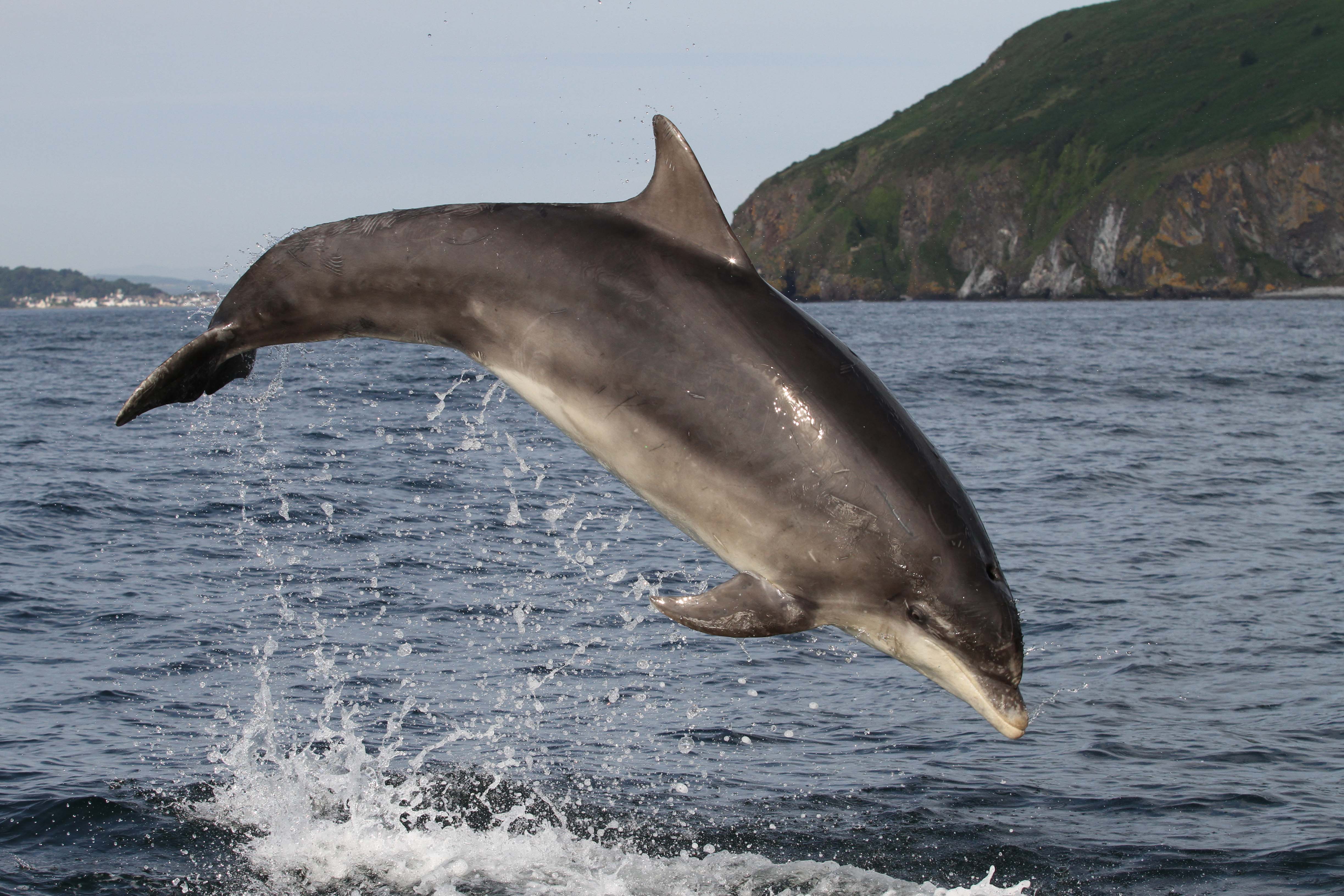
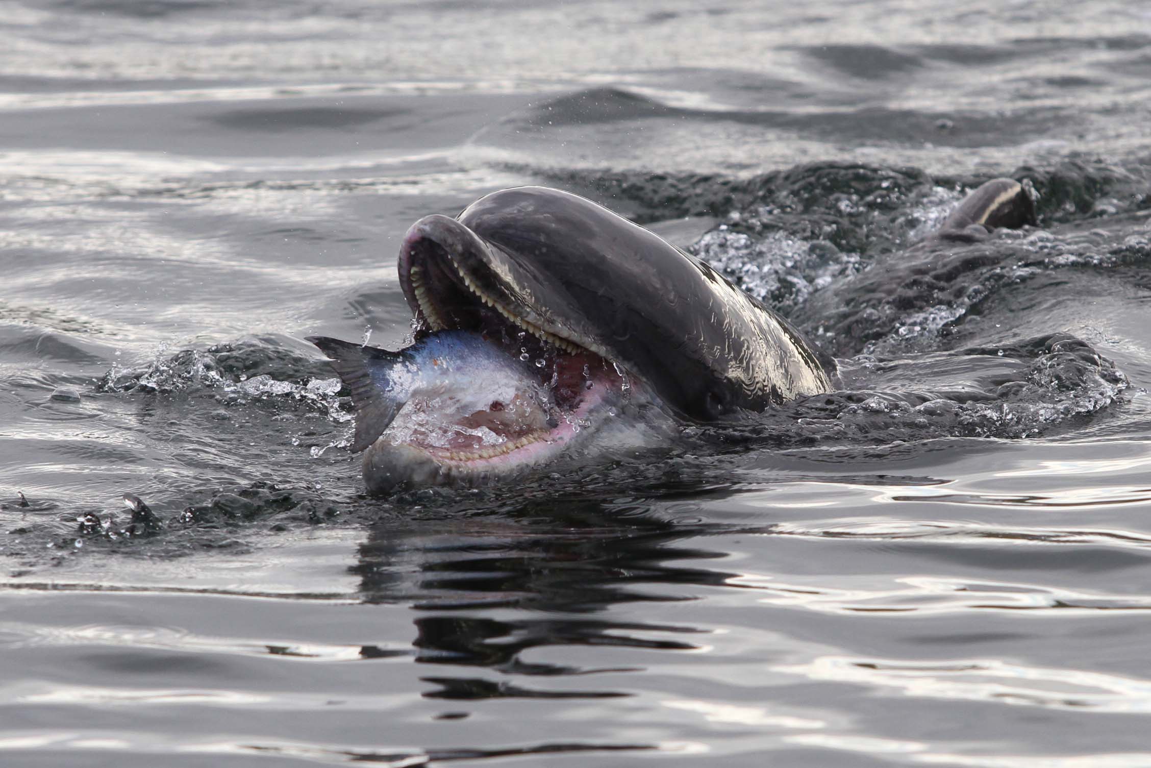
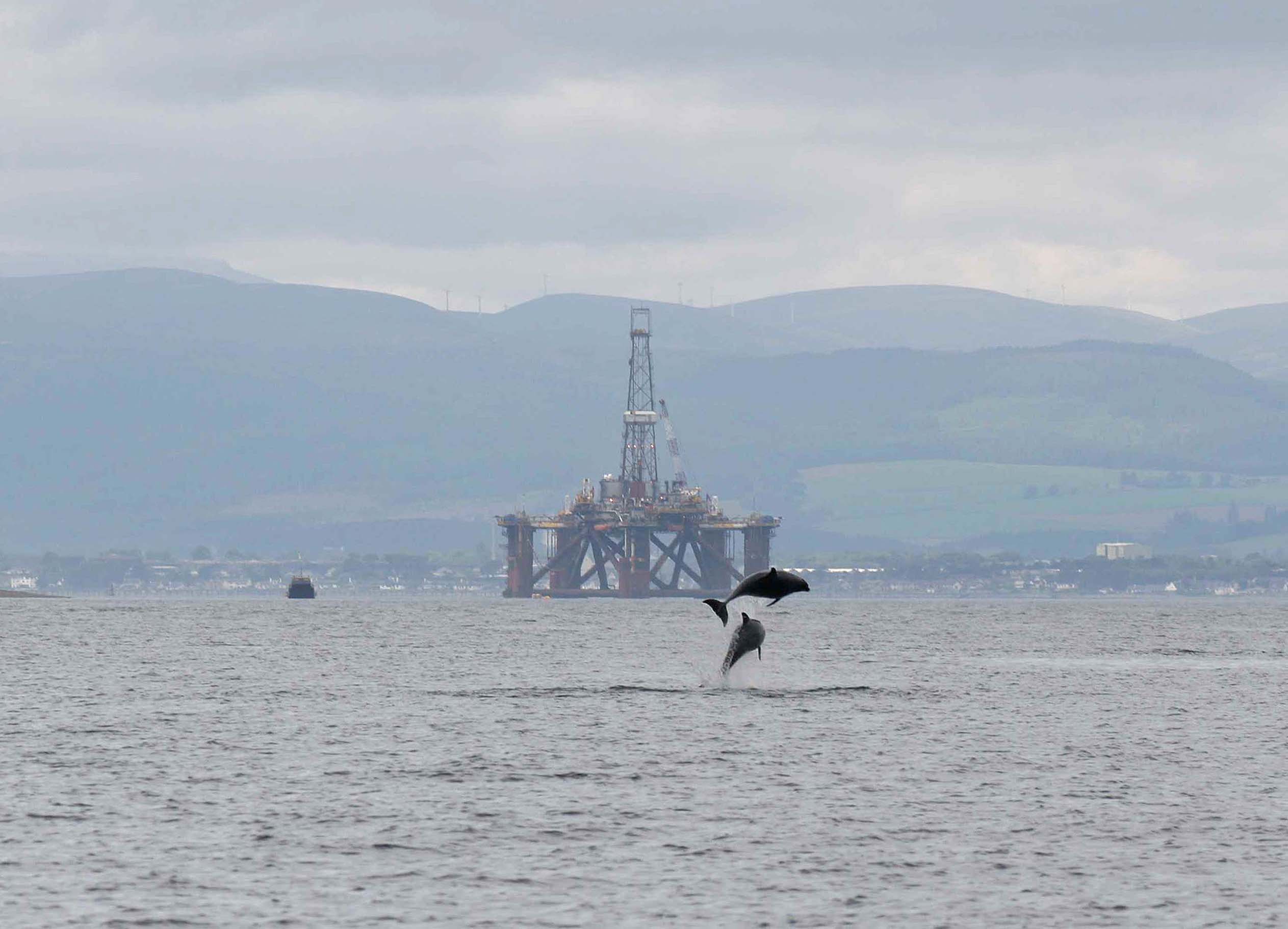
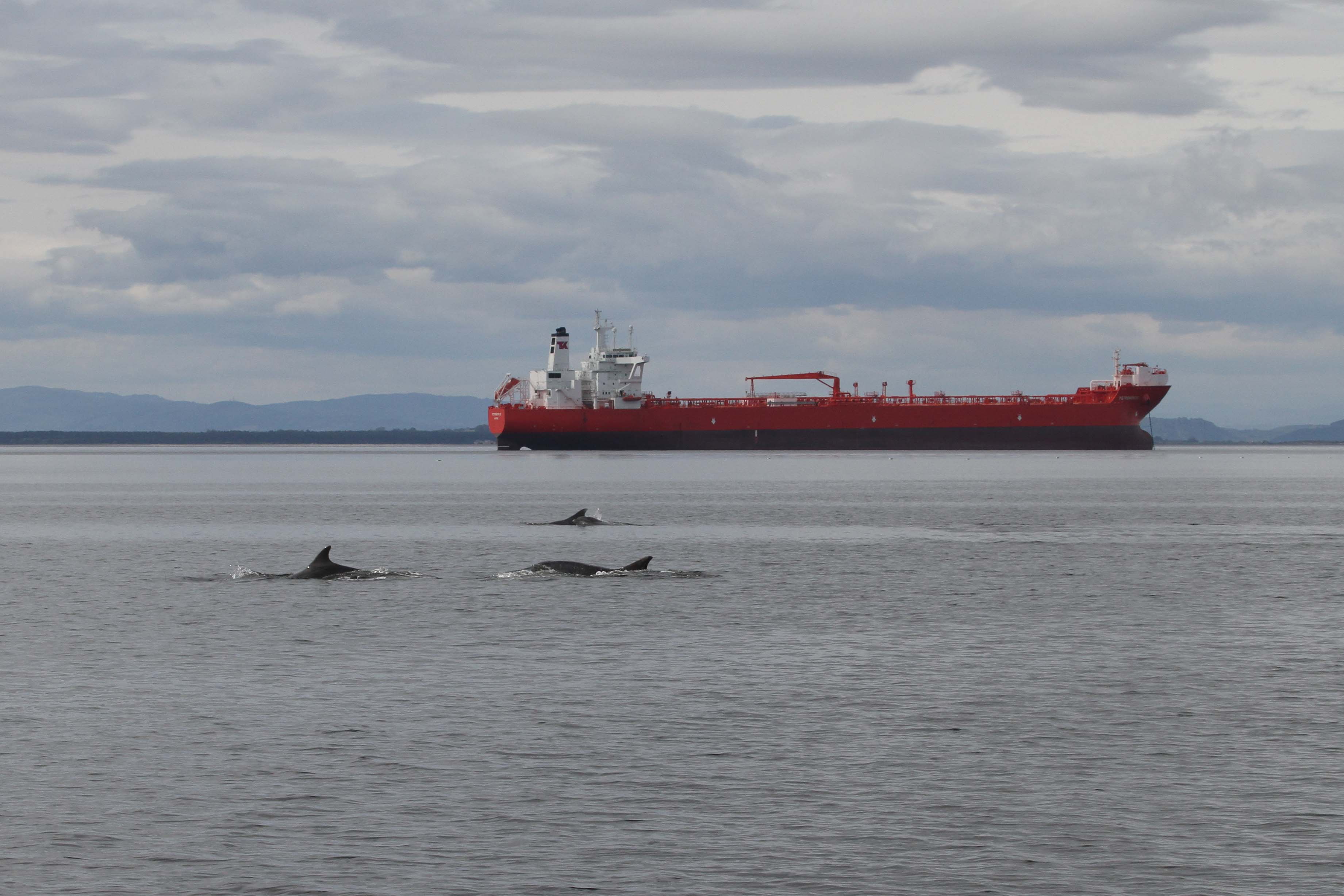
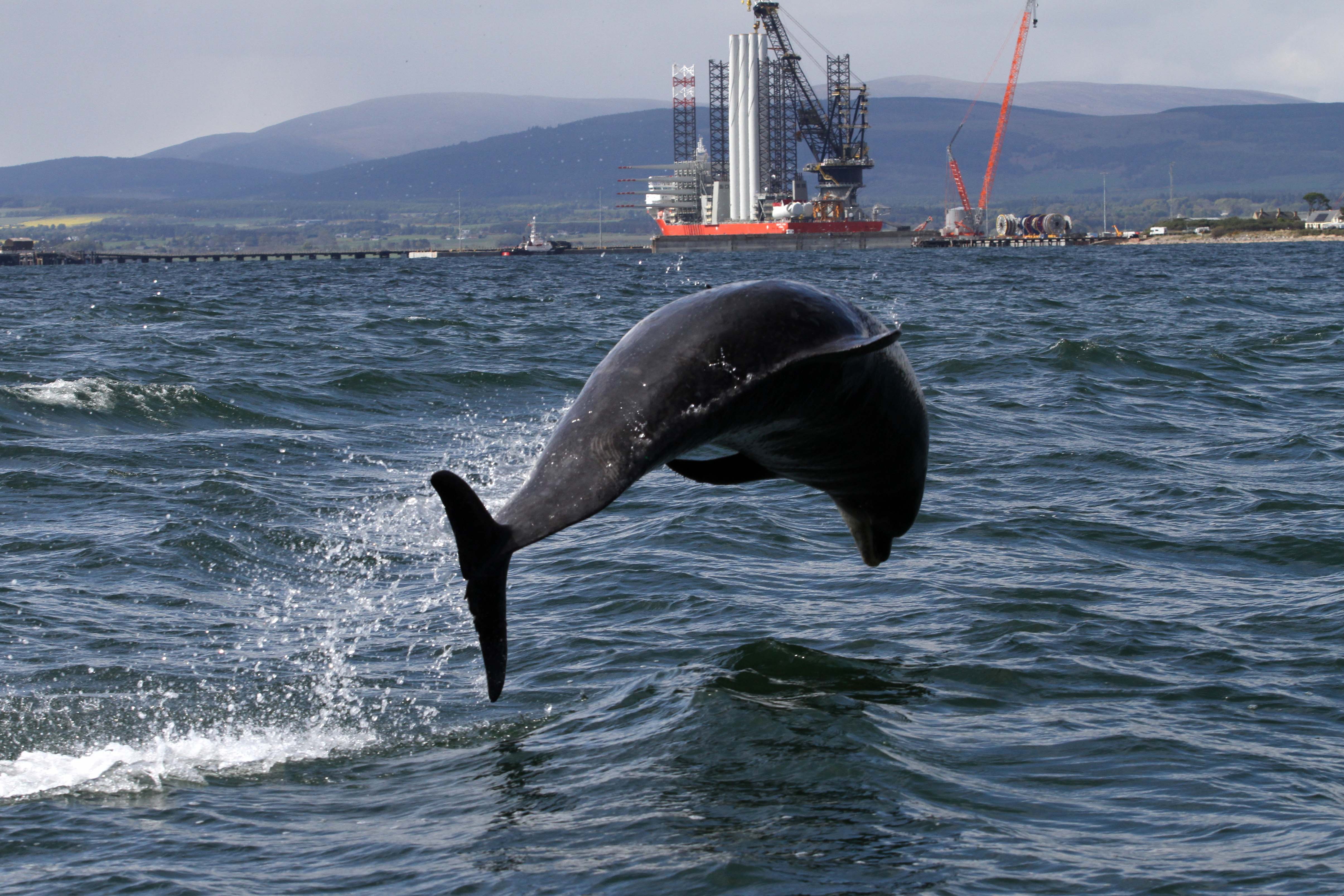
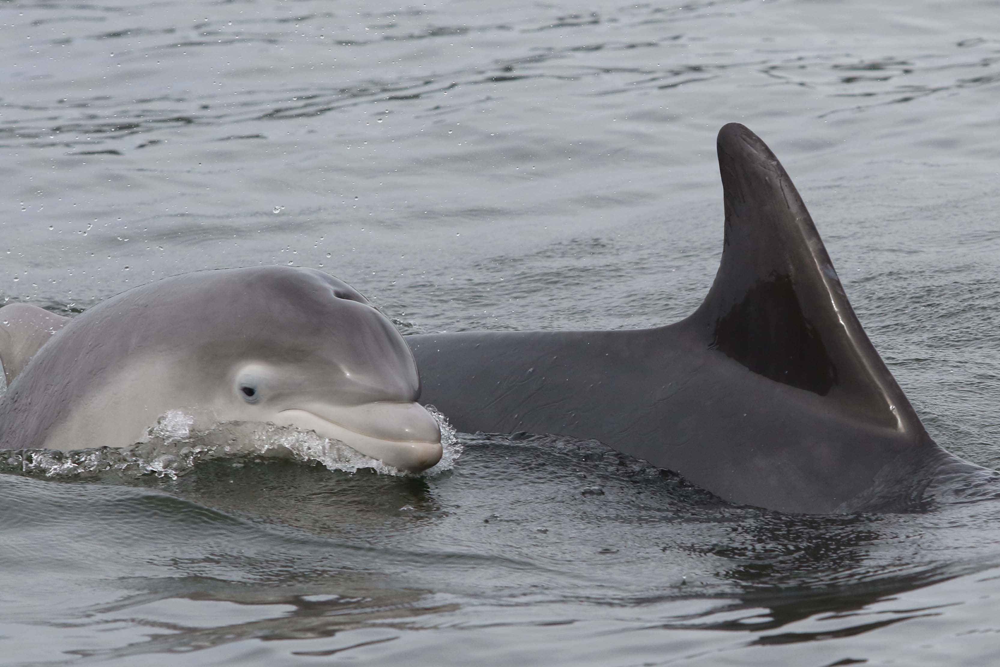
The Moray Firth Special Area of Conservation (SAC), designated in 2005, protects the only resident population of bottlenose dolphins in the North Sea, which is the most northern resident bottlenose dolphin population in the world! In today’s blog, Rona Sinclair from our marine team and Barbara Cheney from the University of Aberdeen dive into the latest monitoring results and research from this important habitat for this population along Scotland’s east coast.
Historically centred around the Moray Firth, there are now estimated to be over 200 bottlenose dolphins that live along the east coast of Scotland. This population of dolphins has been the focus of an intensive research programme, carried out by the University of Aberdeen Lighthouse Field Station in collaboration with the Sea Mammal Research Unit (SMRU) at the University of St Andrews for over 30 years. NatureScot contracts the University of Aberdeen, jointly with SMRU, to make regular status assessments as part of the site condition monitoring programme for the European National Site Network and the Scottish MPA network.
This research and monitoring work is based on the annual collection of photographs of individually recognisable dolphins, identified using nicks and rakes on their dorsal fins. Boat-based surveys are carried out between May and September in both the Moray Firth and the Firth of Tay and adjacent waters. The research in these two locations provides data on abundance, distribution, survival, reproduction, social structure, and body condition. Passive acoustic monitoring of underwater sounds, including dolphin vocalisations and anthropogenic noise, in the inner Moray Firth complements the photo-identification work, providing information on how the dolphins use the SAC and even data on feeding activity.
Since 2014 the long-term monitoring programme in the SAC has been supported through a hugely successful collaboration between industry, universities, nature conservation bodies and government, in the form of the Moray Firth Marine Mammal Monitoring Programme (MMMP). This joint initiative has allowed the continued development of integrated research and an annual monitoring programme. The results have provided a strong evidence base for understanding changes over time in this bottlenose dolphin population and enabled a quantitative assessment of potential impacts for both management and conservation.
The Moray Firth is a busy place and since its designation as an SAC the dolphin population has faced changing pressures in its habitat. This designation provides an additional level of environmental assessment, with the Conservation Objectives seeking to maintain the condition of the bottlenose dolphin population as one of the SAC’s protected features. This designation is also an opportunity for stakeholders to input into decisions being made about activities, has been effective at assessing potential impacts, and has required additional mitigation and monitoring to ensure the site Conservation Objectives are met.
In the early 1990s before the SAC was designated the bottlenose dolphin population in the Moray Firth was thought to be largely contained within the future SAC boundary, and by the time of designation was reported to be in Unfavourable (recovering) condition. This most recent 2024 site condition monitoring report, including new analyses and data collected between 2017 and 2022, shows that the long-term trend (since 2001) in the number of dolphins using the SAC is stable and the use of this protected area continues to be high. However, the short-term trend (over the last 6 years), does show a decline in the number of dolphins using the SAC. At the same time, there has been an increase in the number of dolphins using the Tayside area and adjacent waters. This highlights a need to investigate the potential drivers of this change in habitat use through continued monitoring and further targeted research. Despite this decline in SAC usage, the east coast population continues to increase, with both the SAC and Tayside and adjacent waters being used by more than 50% of the dolphin population in most years.
Results from the latest site condition monitoring report emphasise the need to understand the recent change in use of the SAC. Continued monitoring of both the Moray Firth SAC and East Coast waters is crucial to support future site condition assessments of the Moray Firth SAC and further develop our knowledge of this bottlenose dolphin population. This will ensure a continuity of research and future tracking of trends in abundance, survival and reproduction.
To increase understanding of the use of areas by this population outwith the SAC and Tayside and adjacent waters, the current focussed data collection should be complemented by additional studies. This should include integrating photographs of dolphins from citizen scientists, which have already added to our understanding of the movements of individual dolphins, including the continuing range expansion into northeast England to longer range movements to other parts of the UK and Ireland, and even into European waters. A new programme of work has recently started to improve understanding of the population’s range expansion into NE English waters including quantifying the connectivity of dolphins across its range.
There are also opportunities to investigate whether the change in use of the SAC is due to changing conditions in the Moray Firth habitat or improvements in other areas along the east coast, or both. Ideally future research will focus on ecosystem quality, including stressors and drivers of population change. Surveillance of key habitat features (e.g. prey) and pressures (e.g. vessel activity) could indicate how these are driving changes in dolphins’ habitat use. Vessel traffic within the SAC is expected to increase and ports and harbours are expanding to support offshore energy developments, which present new opportunities to develop our understanding of interactions between bottlenose dolphins and human activity. For example, there is potential for exploiting AIS vessel tracking data and broadband passive acoustic monitoring to evaluate any impacts in key areas of dolphin presence. Also, it is important to explore links between trends in key prey species and observed trends within the bottlenose dolphin population.
Despite the recent decline in the use of the Moray Firth SAC, overall, the news continues to be positive for this small bottlenose dolphin population. Over the longer term the use of the SAC is stable, the use of this protected area is high, and the east coast population is increasing. This has resulted in the current condition status of the Moray Firth SAC being assessed as Favourable (maintained).
In today’s blog, NatureScot’s Ornithology Adviser, Dave Parish gives us an insight into some of the ways farmers are helping to support Scotland’s critically endangered chough.
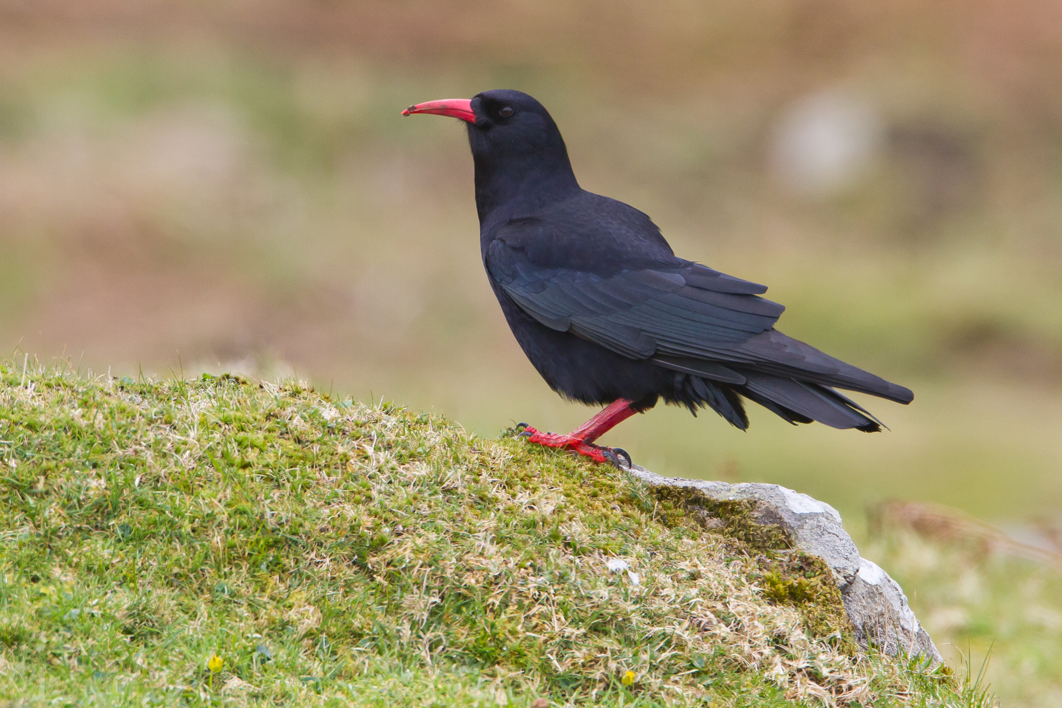
This is an exciting time of year…chough are now laying their eggs at the start of another crucial breeding season. With its striking red bill, the chough is a dapper, medium-sized member of the crow family (hence its proper name, the red-billed chough). The population in Scotland is precarious by any definition with around just 50 pairs left, all confined to the islands of Islay and Colonsay. This means that each breeding season, and each chick successfully raised, is vital to the future of this species.
Choughs usually lay between three and five eggs in a scruffy-looking, large nest made of twigs, often built on top of some kind of large platform. These can be in cracks in cliff faces and the like, or in farm buildings. In some circumstances they will take to nest boxes, but this is not a good idea as the confined space becomes messy with faeces and can cause health problems for the chicks. Farmers in appropriate locations can receive grant funding through the Agri-Environment Climate Scheme to install chough nest shelters, which comprise a large, open nesting platform in the roof space of an appropriate outbuilding. These should give plenty of room for the chicks to grow and move around as they flex their muscles in preparation for flight, and – not to put too fine a point on it – allow them to poo over the edge and so keep the nest relatively clean.
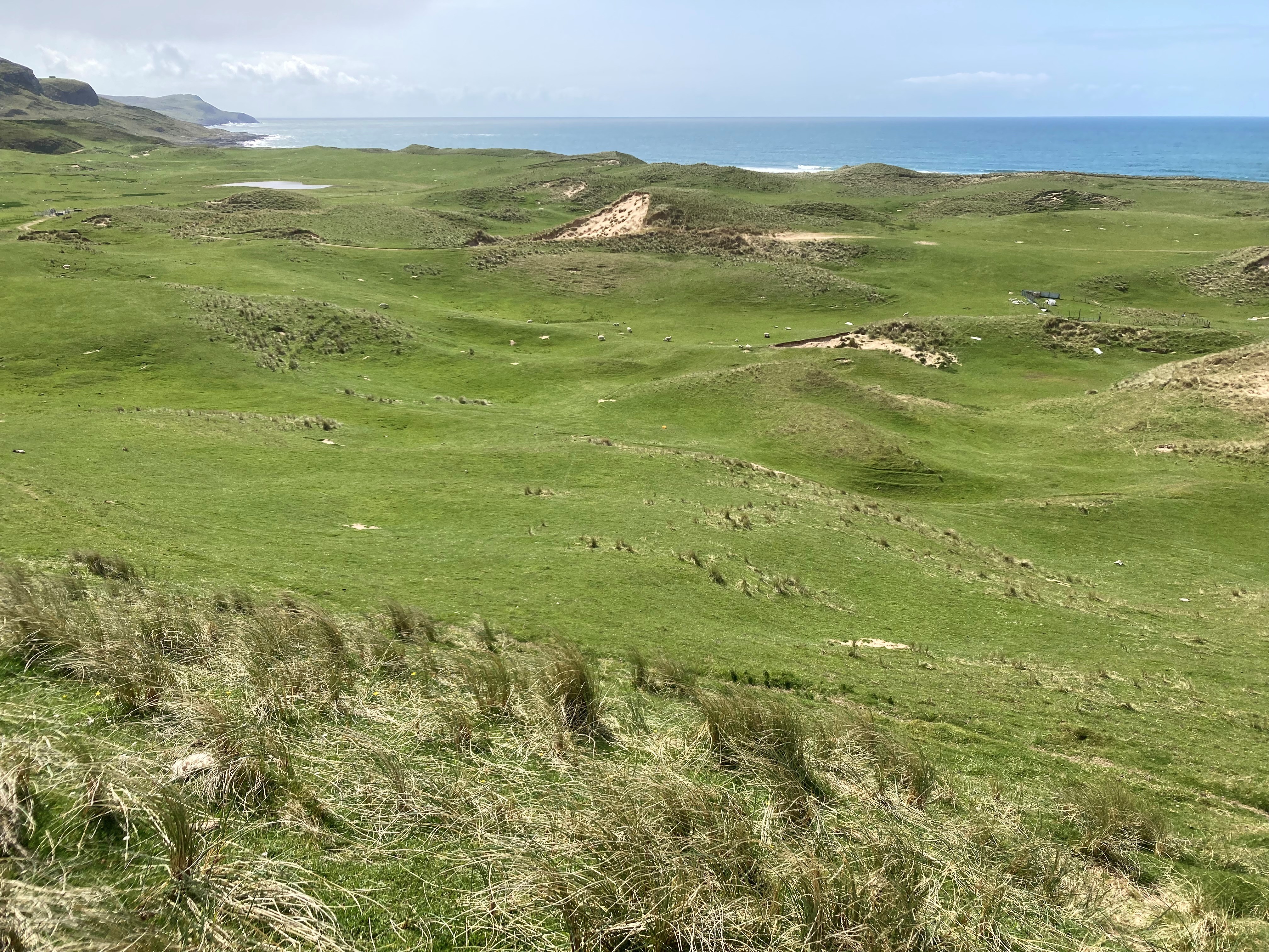
Short, grazed grassland and coastal dune systems are ideal habitat for chough. Kilchoman warren, Islay.
Choughs are dependent upon a relatively low-intensity type of agriculture, where cattle and sheep graze grass fields and the coastal dune systems around the islands for most of the year. This provides the choughs with the preferred short grass in which they search for invertebrates – especially those associated with cow dung. But unfortunately, cow dung isn’t what it used to be. There are fewer cattle on the islands now than in the past, and they are often treated with drugs to tackle potential parasites, drugs which often persist in the dung and deter or kill the beetles and flies that would normally call the dung home, leaving the birds little to eat. This and other agricultural changes mean that young choughs in particular find it hard to find enough food to survive.
Cow dung tends to have fewer beetles and flies on it (chough food) when cattle have been treated with drugs to tackle potential parasites, which can remain in the dung and deter other beasties.
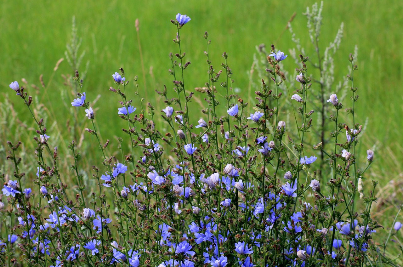
There are ways to help minimise the need for drug treatments, and to check whether livestock need drugs before they are administered. The local vet should be able to advise on this or there are resources online that might help, like Dung Beetles for Farmers. For example, adding chicory and other species into the grass sward at reseeding time, which have anti-parasitic properties and additional fibre, could reduce the need for treatments and help make swards more resilient in the face of changing weather conditions. Similarly, carrying out faecal worm egg counts or simply monitoring body condition closely, can all help identify whether intervention with drugs is needed. There are many other actions that could reduce the reliance on drugs and therefore boost dung-invertebrate numbers (and reduce farm costs), and so provide vital food supplies for young choughs and help change the species’ fortunes.
Adding chicory to the grass sward at re-seeding time could reduce the need for parasite treatment of livestock.
The chough is a protected species – as indeed are all birds during the breeding season – so it is important that they are not disturbed. We are fortunate that choughs in Scotland are very carefully monitored by a group of licenced experts, so in a few months we will know what kind of season it has been and whether the birds have produced lots of chicks. So, keep fingers crossed and watch this space for an update!
Dave Parish is an Ornithology Adviser at NatureScot and specialises in farmland birds, waders and game birds.
When we think of spring in Scotland, we don’t often associate it with wild fires – yet surprisingly the months between March and June are the most likely to see our hills, forests and moors ablaze than any other time of the year.
Despite our often wet winters, the combination of dead and dried out heather, leaves and grasses, and strong, drying winds in spring can spell disaster if a stray spark or cigarette finds its way onto the land. Once ignited, these fires can be very difficult to put out, not only damaging the landscape but also putting firefighters’ live at risk and threatening people, wildlife and property.
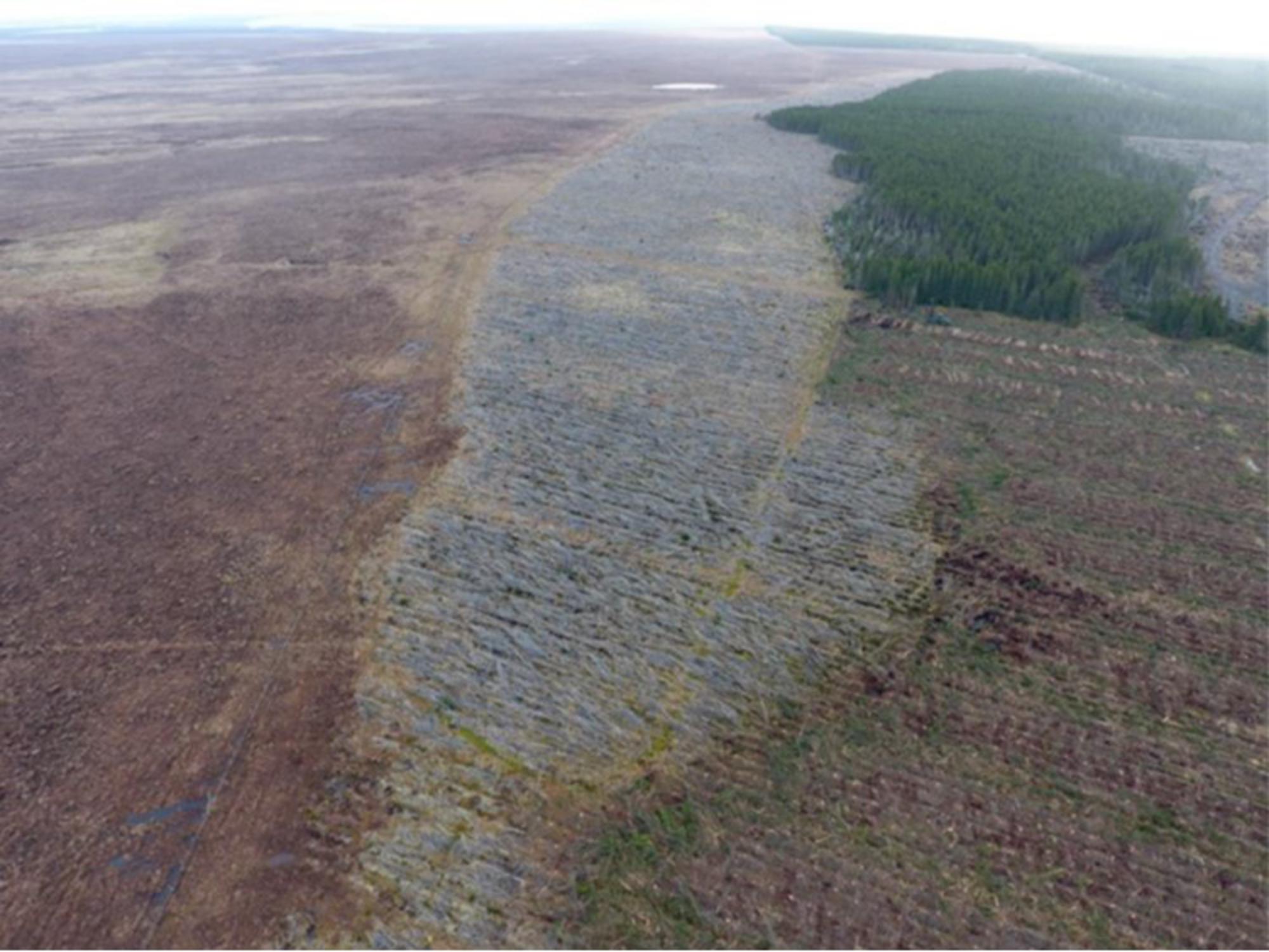
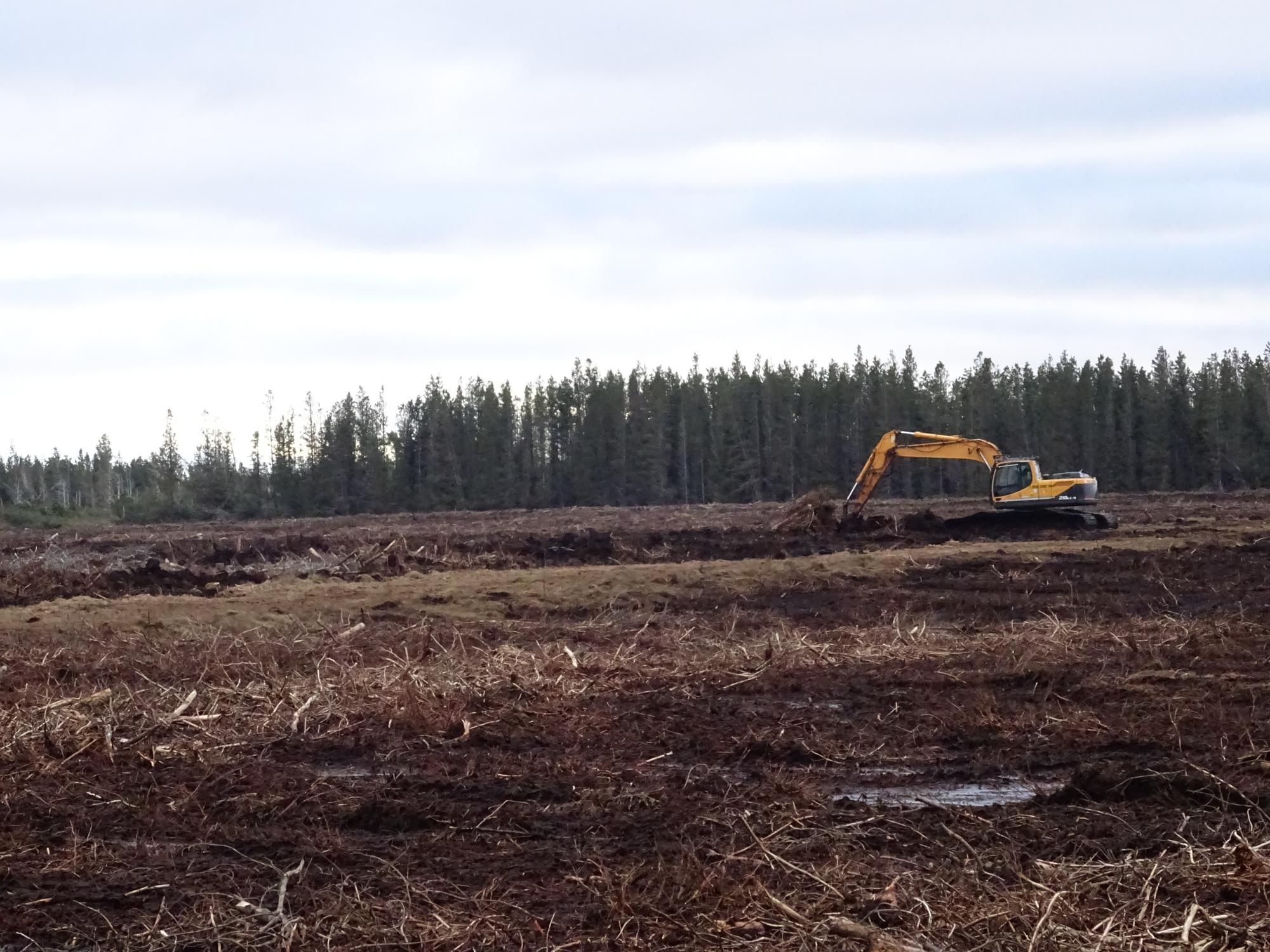
In 2023, it was reported that there was at least one fire every day between March and June – over a third of them in the Highlands. Since then, there have been a number of initiatives to identify the best ways to avoid wild fires. This is why Peatland ACTION is keen to highlight the role peatland restoration can have in preventing their spread. By rewetting the land, restoration makes it much more difficult for fires to start, or to spread across them from elsewhere.
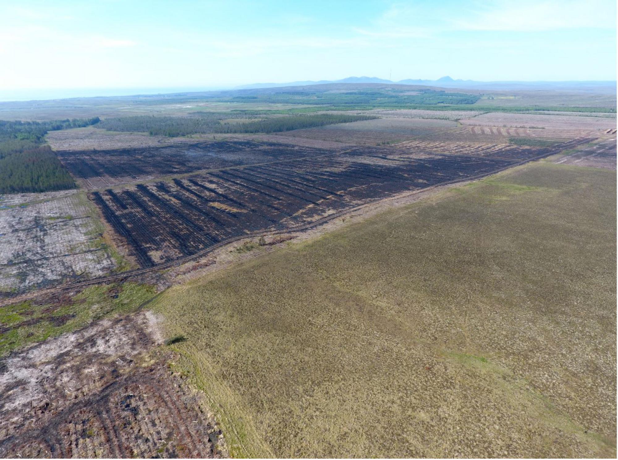
When fire took hold across the forestry and moors above Lybster in Caithness in 2018, it burnt everything in its path – until it came to the recently restored peatland at Golticlay. The work here to smooth out the furrows and ridges left in the peatland after the forestry had been removed raised the water table. This meant the ground surface and vegetation were too wet for the fire to spread. It was a dramatic example of healthy peatlands’ ability to prevent the spread of wildfires.
The combination of the wetter surface, thanks to the higher water table, an increase in peatland vegetation, and the removal of scrub on the areas where peatland restoration work had taken place stopped the fire in its tracks—with the stark line between scorched black and lush green clear to see from the air. You can read the full case study on the Peatland ACTION website.
Peatlands in good condition are one of the most robust open habitats found in Scotland’s landscape, along with other wetlands. However peatlands that have been damaged, for example where drainage has been installed, are likely to suffer more severe fire damage and spread fires to neighbouring areas. They usually support the growth of heathy or grassy vegetation, increasing the amount of fuel available and drying out the layer of peat nearest the surface.
This evidence is more than anecdotal. The Fire Blanket project, a research programme led by a team from the University of Highlands and Islands from 2019-21, compared the fire resilience of blanket bogs under different management regimes using measures of vegetation, moisture, peat properties, satellite-derived “bog breathing” and water quality.
They used a major wildfire that happened at Strathy, in the Flow Country, in 2018 as the study site. The project concluded that ‘restoration is likely to increase wildfire resilience and reduce wildfire severity. This in turn should help minimise the carbon losses and biodiversity impacts associated with these events.’
Of course, in an ideal world we wouldn’t have these fires in the first place. Most of them are started either accidentally or deliberately by people, and by following a few simple guidelines many of them can be avoided. If you are out in the countryside, please follow Scottish Fire and Rescue Service’s guidance https://www.firescotland.gov.uk/outdoors/wildfires/wildfire-prevention/
Follow the Scottish Outdoor Access Code’s advice and never start a fire when a wildfire danger assessment is in place and during prolonged dry periods in areas such as forests, woods, farmland or peaty ground.
Don’t have BBQs on any flammable surface during very dry and prolonged weather. Instead have them within safe designated BBQ areas.
Don’t have campfires or any outdoor fire when a wildfire danger assessment is in place or during prolonged dry periods.
Always fully extinguish cigarettes and dispose of them responsibly.
Don’t leave litter; take it home with you and leave no trace. Glass in direct sunlight can cause a fire. Ensure none is lying around.
Where possible, use a stove rather than an open fire.
If you do light a fire, keep it small, controlled and supervised.
Make sure the fire has been fully extinguished and remove all traces of an open fire before you leave the area.
From drones to artificial intelligence (AI), new technologies are changing the face of wildlife management. In today’s blog, our wildlife management officer Nathan Berrie looks at some of the advantages – and limitations – of these new tools for monitoring deer populations.
Deer are an important part of our biodiversity, but in high numbers they can have a negative impact on woodlands, peatlands and other habitats. Sustainable deer management is vital if we are to meet ambitious and necessary targets to restore nature and tackle climate change.
In its report to the Scottish Government in 2020, the independent Deer Working Group highlighted the need to embrace technology to better understand the challenges and opportunities when managing deer. As the urgency around the nature and climate crises has increased, and with it a move towards more conservation management of deer, innovation in the sector has accelerated.
One area where tech is increasingly being developed and deployed is deer counting. Knowing how many deer use an area is important to determine how to manage populations sustainably. Historically, helicopters have been used and they remain our primary method of counting. However, alternatives are being explored to lower carbon emissions, cut costs and increase efficiency.
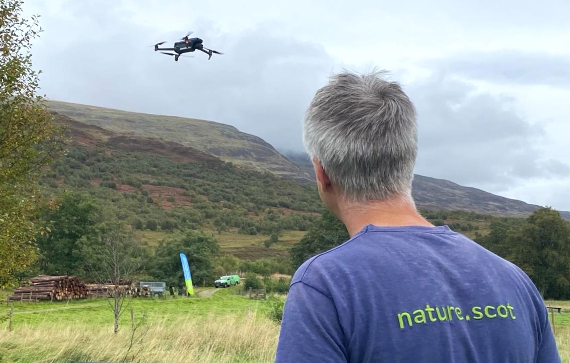
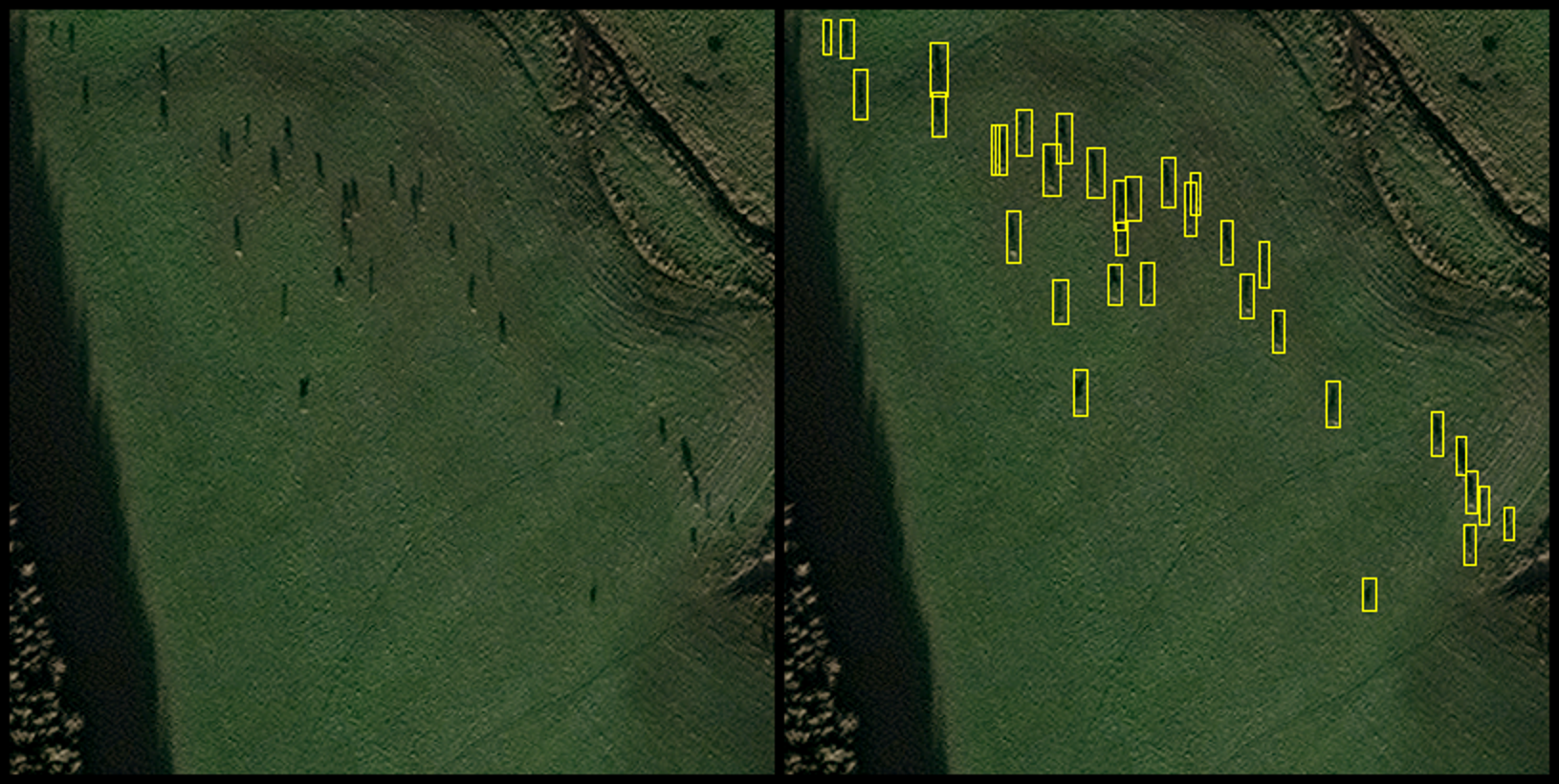
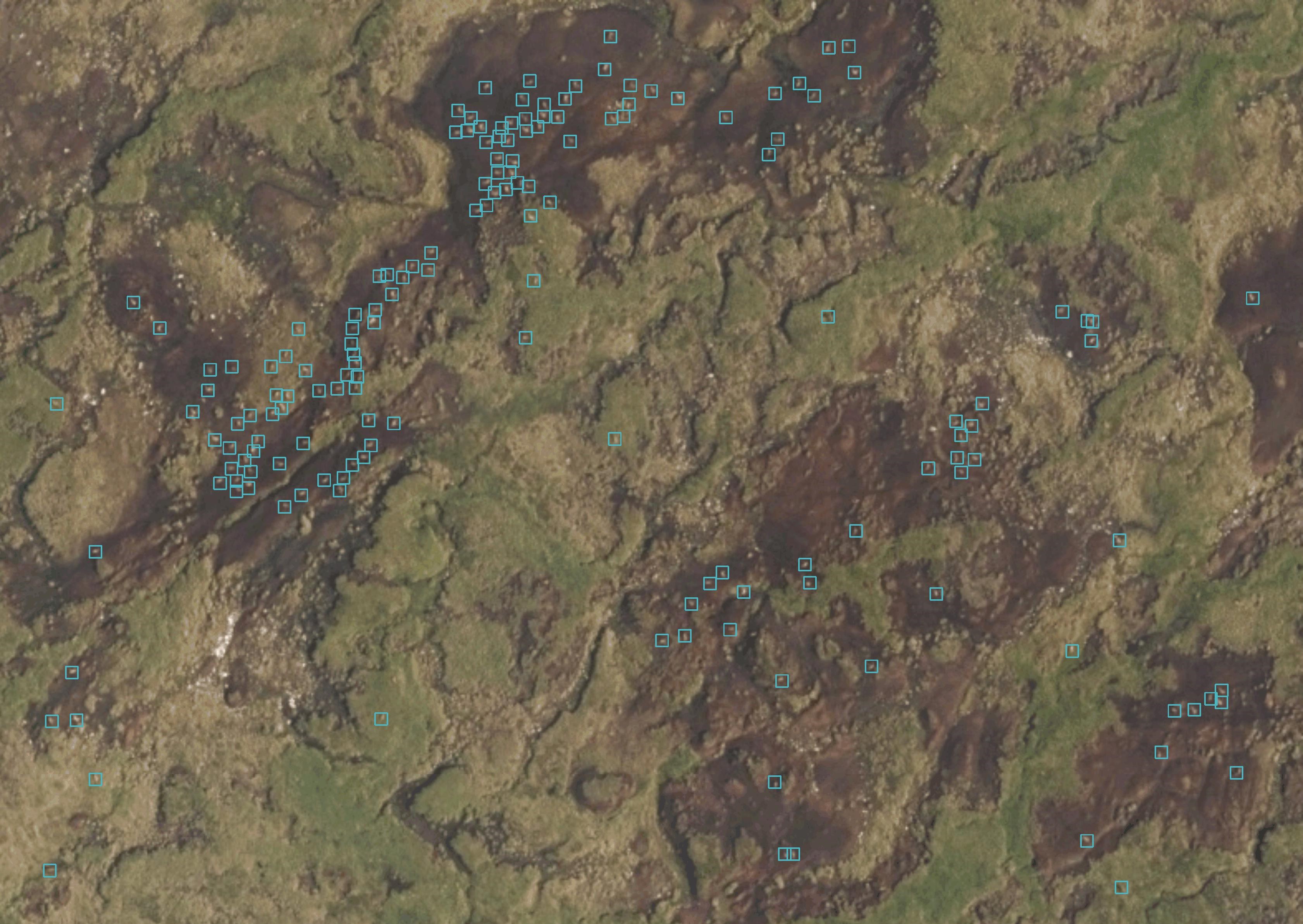
Most notably, thermal drones have offered an alternative method in specific situations. Working with B&H Wildlife Consultancy, NatureScot recently completed a thermal drone count at our Taynish National Nature Reserve. This count offered a valuable insight into deer populations at the reserve, including minimum population during the survey, species classification and population movements. Along with robust habitat impact assessments, this data can help support our decision making on deer management.
Thermal drones do have their limitations though. Legal flight requirements stipulate a maximum flight distance of 500 meters and keeping the drone within line of sight. The need to continually move to the next survey point risks disturbing deer and skewing the results. Alongside battery lifespan, weather conditions and limited ability to classify sex and age, drones can struggle to provide results in many landscape-scale situations.
Several other novel approaches may offer solutions. Supported by the Scottish Government’s CivTech programme, NatureScot worked with EOLAS to explore using existing satellites and a newly developed wildlife artificial intelligence (AI) image recognition tool. Although in its infancy, the technology showed promise and has the potential to provide swift and accurate data across a larger area of open land. With further development it could provide real-time and frequently updated population information.
Again, much like drones, the technology has its limitations. Limited image resolution currently makes it challenging to classify sex, age and possibly species of deer. Furthermore, if higher resolution images are developed, there are data storage implications due to the image size. But most of all it is the good old-fashioned Scottish climate that creates the biggest challenge. According to the Met Office, Scotland’s average annual sunshine hours over the whole country are 1,160, meaning that the sun shines just over 25 per cent of the time. Nevertheless, if conditions allow, this technology can be successful. So much so that it is now being used by EOLAS to help conservationists count African elephants.
Another alternative method may help overcome the cloud cover challenge. In phase two of the CivTech project, lightweight manned aircraft that can fly below the cloud cover were trialled. Significantly greener than helicopters, these light aircraft can cover large areas and collect high-resolution images which could be run through the AI software. This technology could allow deer to be classified as stags, hinds, calves and could also be more useful for looking at habitat type and condition—something which current satellites are incapable of.
Whether new or old, each monitoring method has its place depending on management needs. At present, helicopters will be faster and more efficient when faced with numerous priority sites that need counted. And while it can be easy to get excited about a new shiny bit of kit, in truth the conventional dung or foot count may give wildlife managers a better indication of how many deer are on the ground.
There’s no doubt that new technologies are already adding increased flexibility and efficiency for deer managers but looking to the future, it’s likely that a combination of new and traditional methods will be used to get the most accurate outcome.
This article first appeared in issue 69 (Spring 2024) of the Reforesting Scotland Journal.


You must be logged in to post a comment.